Hello, and welcome back to my Puerto Rico travel journey. On this website, I’ve shared the best places, resorts, beaches, local foods, tours, festivals in Puerto Rico, and the mistakes people often make while traveling.
In this guide, I’ll tell you about the municipalities and cities of this island. There are a total of 78 municipalities in Puerto Rico, so this article might be a bit long. But don’t worry, it will be entirely worthwhile. After reading this guide, you may never need to search for PR’s cities and municipalities again.
So read at your own pace, save this post, and let’s break down these big numbers in an easy, memorable way.
78 Municipalities and Cities of Puerto Rico at a Glance
A – Adjuntas, Aguada, Aguadilla, Aguas Buenas, Aibonito, Añasco, Arecibo, Arroyo
B – Barceloneta, Barranquitas, Bayamón
C – Cabo Rojo, Caguas, Camuy, Canóvanas, Carolina, Cataño, Cayey, Ceiba, Ciales, Cidra, Coamo, Comerío, Corozal, Culebra
D – Dorado
F – Fajardo, Florida
G – Guánica, Guayama, Guayanilla, Guaynabo
H – Hatillo, Hormigueros, Humacao
I – Isabela
J – Jayuya, Juana Díaz, Juncos
L – Lajas, Lares, Las Marías, Las Piedras, Loíza, Luquillo
M – Manatí, Maricao, Maunabo, Mayagüez, Moca, Morovis
N – Naguabo, Naranjito
O – Orocovis
P – Patillas, Peñuelas, Ponce
Q – Quebradillas
R – Rincón, Río Grande
S – Sabana Grande, Salinas, San Germán, San Juan, San Lorenzo, San Sebastián, Santa Isabel
T – Toa Alta, Toa Baja, Trujillo Alto
U – Utuado
V – Vega Alta, Vega Baja, Vieques, Villalba
Y – Yabucoa, Yauco
Quick Overview
| Requirement | Municipality / City |
| Largest by Area | Arecibo |
| Smallest by Area | Cataño |
| Biggest by Population | San Juan |
| Smallest by Population | Culebra |
| Best for Stay | San Juan, Rincón, Ponce |
| Best for Beach Visits | Culebra, Rincón, Cabo Rojo |
| Best for Food | Cayey |
| Not Crowded | Maunabo, Cabo Rojo |
| Most English Spoken | San Juan |
| Best for Overall Visit | San Juan |
The Metro Region: Where Most People Start
San Juan
It is located on the northeastern corner of the island and has been the capital of Puerto Rico since the Spanish colonial era. Its population is approximately 395,000, but if the surrounding municipalities are included, the entire metropolitan area’s population exceeds 2 million.
Most tourists arrive at “Luis Muñoz Marín International Airport”, which is technically located in Carolina, not San Juan. However, for most people arriving by air, it is practically considered San Juan. From there, tourists head to the city’s various areas, which are often collectively referred to as “San Juan.”
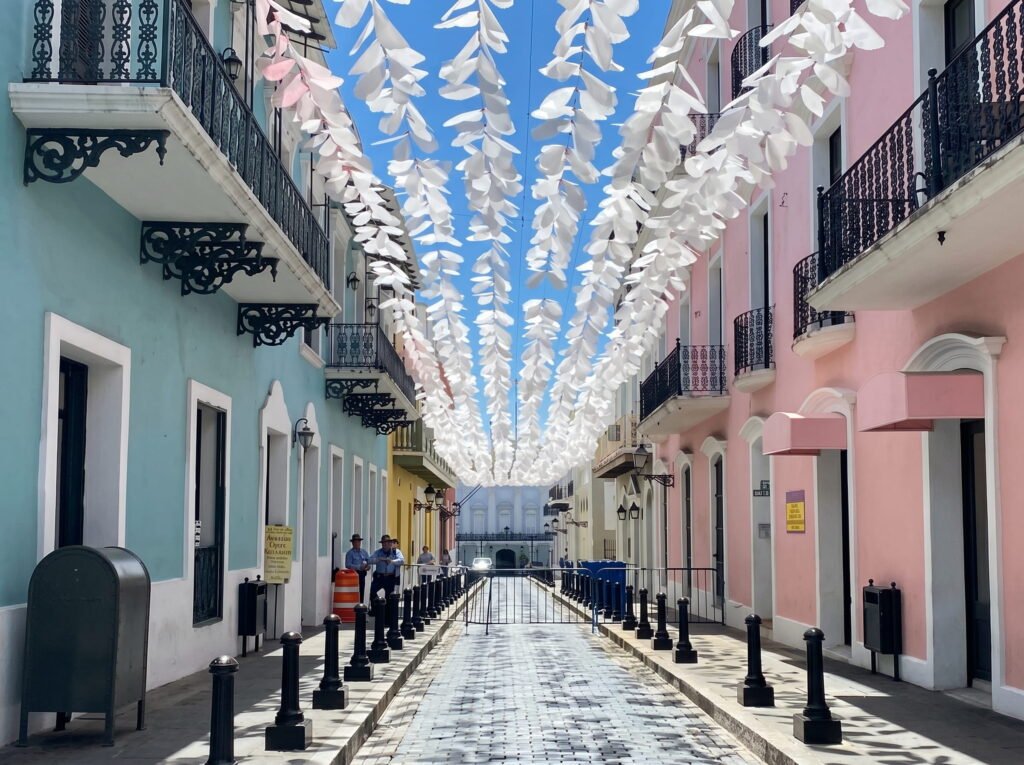
Old San Juan
It is the part of San Juan that comes to mind when people think of the city. It is an area of about seven blocks on a peninsula, featuring cobblestone streets and Spanish colonial-style buildings. These buildings are painted in beautiful shades of ochre, blue, ochre-tan, and yellow, giving the entire area a unique charm.
The two historic forts here — “El Morro”, located on the northwestern shore, and “Castillo San Cristóbal”, located near the eastern gate — were built in the 16th century.
Despite facing countless challenges and historical events over the centuries, these forts still stand strong today and are considered an important part of Puerto Rico’s historical identity.
Condado
Condado is a modern, beachfront neighborhood located east of Old San Juan. It’s easy to get around on foot, it’s packed with large hotels, and along the streets you’ll find high-end restaurants, boutiques, and ocean-view bars. It’s the kind of place where people often go in for a drink and end up staying for a few hours.
Its beach is more famous for its beautiful scenery than for swimming, as the ocean waves and currents can sometimes be quite strong. However, it’s considered the best spot for people-watching, enjoying the atmosphere, and savoring top-notch cuisine.
Santurce
Santurce is the neighborhood where local artists, creators, and young professionals live in large numbers. It has a vibrant, ever-changing vibe. Street art can be seen on nearly every other building, the art and culture scene is very active, and The food market called La Placita de Santurce turns into a large open-air party on weekends.
Calle Loíza
Running through the area is lined with cafés, vintage shops, and popular spots that may not even have a big sign out front, but are always packed inside.
This is also where the Museo de Arte de Puerto Rico is located. In Santurce, you see the real San Juan that often doesn’t appear in tourist brochures.
Ocean Park, located between Condado and Isla Verde, is a relatively calm, residential beach area. Here you can see the island’s best kitesurfers, the local coffee shops are excellent, and the beach is considered more suitable for swimming.
Isla Verde
Isla Verde is a famous resort area where large hotels, casinos, and towering buildings line a beautiful beach. Technically, it’s part of Carolina, not San Juan, but in practice the difference is barely noticeable. The Fairmont El San Juan Hotel is the area’s most prominent landmark.
If you want to spend a resort-style vacation, it’s the perfect place, but it’s not considered as interesting for getting a close look at Puerto Rico’s local culture and everyday life.
Bayamón
Bayamón is located west of the capital and, with a population of about 170,000, is Puerto Rico’s second-largest municipality. Locally it is known as **” El Pueblo del Chicharrón,” a name that refers to its famous tradition of making fried pork rind (chicharrón). It is a busy, relatively suburban city that also features a science park and a historic trolley.
Carolina
It is located east of San Juan and is home to “Luis Muñoz Marín International Airport” and “Isla Verde”. With a population of approximately 148,000, it is considered one of Puerto Rico’s major commercial municipalities.
Cataño
It is the smallest municipality in Puerto Rico by area, with a total land area of less than 5 square miles. Despite its small size, its importance is much greater. It is home to one of the world’s largest rum distilleries, the “Bacardí Distillery”.
It can be easily reached by ferry from Old San Juan, where tourists enjoy distillery tours and tasting experiences.
Guaynabo
Guaynabo is located south of the capital and is considered one of Puerto Rico’s relatively more prosperous municipalities. It has corporate offices, upscale residential areas, and good restaurants. If you’re staying in San Juan and want to eat beyond the tourist areas, Guaynabo offers several great options that are well worth the short drive.
Caguas
Caguas is a larger city located further south with a population of about 115,000. It is considered an important commercial center for central Puerto Rico. It has a strong arts center, a beautiful botanical garden, and a downtown plaza where people are actually present and life feels alive.
Most tourists who limit themselves to the metro area overlook this city, but if you’re heading toward the mountain regions, it can make for a great stop.
The North Coast: Porta Atlántico
If you head west from San Juan along the Atlantic coast, you enter a coastal region made up of several municipalities that most tourists completely overlook, even though they shouldn’t.
Dorado
Dorado is the place to go if you want a beach and to avoid crowds like those in San Juan. Here you’ll find clean, peaceful beaches, some high-quality resorts, and very relaxed atmosphere. It’s located about 30 minutes from the capital.
Arecibo
Arecibo is the largest municipality on the entire island, covering over 125 square miles. It’s located on the north coast about an hour from San Juan. Most people know it for the “Arecibo Observatory”, which was once the world’s famous radio telescope. Although it was closed after a structural collapse in 2020, it remains a major attraction.
Arecibo is known for the “Arecibo Observatory”, which was once the world’s most famous radio telescope. Although it was closed after a structural collapse in 2020, the site and museum that replaced it are still worth visiting.
Arecibo also has the “Lighthouse and Historical Park”, as well as the “Cueva Ventana” — a cave with a window-like opening offering a spectacular view of the valley below. There is the “Camuy River Cave Park”, which is considered one of the largest cave systems in the Western Hemisphere.
Manatí and Barceloneta are relatively quiet coastal towns where you’ll find local beaches, a presence of the pharmaceutical industry, and an overall slower, more relaxed pace of life compared to the metropolitan area.
Hatillo, Camuy and Quebradillas are located in the northwestern corner of the northern coast. These areas largely escape the notice of tourists but are very popular with locals.
They also have beautiful beaches, and the towns.
The West Coast: Porta del Sol
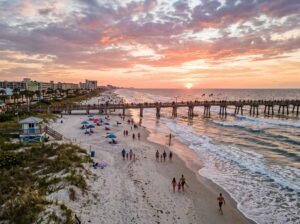
In the west, the island’s character changes most distinctly. Here the Atlantic Ocean ends and the Caribbean Sea begins. The sunsets here are truly spectacular. This area is also the surf capital of Puerto Rico, and the whole region feels more free, laid-back, and relaxed, especially compared to the metro.
Rincón
Rincón is the name that first comes to every surfer’s lips. The World Surfing Championships were held here in 1968, and its reputation has endured ever since—and with good reason, because its beaches like “Domes and María’s” really deliver world-class waves. But even if you don’t surf, Rincón is still worth visiting.
It’s a small, slightly hippie-style beach town with good restaurants, inexpensive to mid-range guesthouses, and a very relaxed atmosphere. During the winter months, there’s also a chance to see whales here (humpback whales pass through from December to March).
The sunsets over the water are so stunning.
Aguadilla
Aguadilla is considered the gateway to the northwestern region. There is also an airport here (Rafael Hernández Airport). where some direct US flights also arrive. The city is famous for its surfing beaches, especially Crash Boat and Gas Chambers, which attract serious surfers.
This area is more industrial than Rincón, but if your goal is just beaches and water activities, this place is truly the best.
Isabela
Stretches along the northwestern coast, and its long, golden sandy beaches are very famous. “Playa Jobos” is the area’s main and most beautiful beach. It’s also a great spot for kitesurfing, and the whole town maintains a relatively peaceful, local way of life.
Mayagüez
Mayagüez is Puerto Rico’s third-largest city and is considered the main regional center of the western region. Its population is approximately 70,000. Locally, it is known as “El Sultán del Oeste,” meaning “the Sultan of the West.” Here you’ll find the “University of Puerto Rico–Mayagüez”, the historic “Teatro Yagüez”, and the impressive “Plaza Colón”, where bronze statues are installed.
Mayagüez mostly feels like a working city rather than a tourist destination. However, its zoo is considered one of the best in the Caribbean, and the food scene is also quite strong.
Cabo Rojo
Cabo Rojo is located on the southwestern tip of Puerto Rico and is considered one of the most charming areas on the entire island. The salt flats here turn pink at dusk. The Los Morrillos Lighthouse, perched on cliffs above the sea, is a prominent landmark of the region. “Boquerón” is a coastal town whose long, tranquil bay is perfect for family outings. And despite its name, “Playa Sucia” is often counted among Puerto Rico’s best beaches.
The entire region around Cabo Rojo and its nearby area, Lajas, has a distinct atmosphere. The land here is mostly dry and sun-drenched, with cacti more common than palm trees, the light is very bright, and the beaches feel remote even if they aren’t actually far away.
Guánica
It is located east of Cabo Rojo and here “The Bosque Estatal de Guánica”, a dry forest reserve and part of the UNESCO Biosphere Reserve, is located here. It is completely different from most of the rest of the island, as its environment is semi-arid, home to cacti, iguanas, and various birds. Its beaches are calm, shallow, and often nearly empty.
San Germán
San Germán is located inland on the southwest coast and is one of the island’s oldest cities, founded in 1573. The city’s main square and historic district are almost intact. Here, the “Porta Coeli Church”, one of the oldest churches in the Americas, still stands above the plaza.
The South Coast: Porta Caribe
The southern coast of Puerto Rico receives less rainfall than the north and faces the Caribbean Sea rather than the Atlantic. The climate here is warmer and drier.
The towns in this area are older and more traditional, and the pace of life throughout the region is quite slow, forcing you to relax and take it easy.
Ponce
Ponce is the anchor. Second-largest city in Puerto Rico, founded in 1692 by a great-grandson of Ponce de León — and yes, the city is actually named for the family. Population around 144,000.
Called “La Perla del Sur” — the Pearl of the South — and it earns it. The historic center around Plaza Las Delicias is one of the most beautiful urban plazas in the Caribbean. The cathedral of Nuestra Señora de Guadalupe dates to the 17th century. The Parque de Bombas — the 1883 firehouse in its striking black-and-red Victorian pattern — is an icon.
The Museo de Arte de Ponce holds one of the finest art collections in Latin America. And La Guancha, the seaside boardwalk, is lined with seafood kiosks and has an energy at night that surprises people who expected a quieter city.
It’s about 90 minutes from San Juan on the highway. A lot of visitors never make it here. That’s honestly their loss.
Coamo
Just north of the south coast is one of the oldest towns in Puerto Rico, established around 1579, and holds some of the island’s most storied thermal hot springs — Baños de Coamo, used since the time of the Taíno. A quiet, historic town worth an afternoon.
Salinas and Guayama on the southeast end of the south coast are known for fishing, traditional food, and the kind of community festivals that draw local crowds rather than tourist buses. Guayama also has a well-preserved historic center. Not on the usual itinerary. Genuinely worth finding.
Yauco
Yauco in the southwest is coffee country. The mountains behind it produce some of the island’s best coffee, and the Yauco National Coffee Festival runs every February. The town square has been painted in a coordinated mural project that makes the whole place look like an outdoor gallery.
The East Coast: Porta del Mar
The eastern region is where you’ll find rainforest, small islands, and some of the island’s most peaceful beaches.
Luquillo
Luquillo is the town closest to El Yunque, and its “Balneario de Luquillo” is one of the island’s most popular public beaches. It’s a wide, crescent-shaped shore where the water is generally calm.
Along the beach there is a row of kiosks where local foods like alcapurrias, piñon, and empanadillas are available. Many people say that these kiosks alone are a big reason to come here.
Río Grande
Río Grande is the municipality that encompasses most of the El Yunque National Forest. It is the only tropical rainforest in the entire US National Forest System, covering approximately 28,000 acres. Here you’ll find dense forests, waterfalls, hiking trails, and unique native wildlife. “La Mina Falls” and “La Coca Falls” are the most visited waterfalls here.
The best time to go is early in the morning, because by 11 a.m. the parking lot fills up and the trail to the main waterfall gets quite crowded.
Fajardo
Fajardo is located on the northeastern tip and serves as an important transportation hub for the outer islands. The ferries to Vieques and Culebra actually depart from nearby “Ceiba”.
Fajardo itself is also interesting. There’s a marina district called “Las Croabas” where boat tours are available, and also access to “Reserva Natural Las Cabezas de San Juan” is also available.
This natural reserve includes a bioluminescent bay, which is less famous than Vieques’ Mosquito Bay but still very beautiful, and it also features a historic lighthouse. Snorkeling around the cays in this area is considered one of the best activities to do easily from the island’s main part.
Humacao
Humacao is located further south on the eastern coast and is considered the gateway to the “Palmas del Mar” resort area. It is the largest resort complex on the entire island, featuring its own marina, golf courses, and beautiful beaches.
Loíza
Loíza is a very important cultural city located north of Fajardo. It is considered the area with the largest Afro-Puerto Rican population in Puerto Rico and is deeply connected to the birth of bomba.
Bomba is a traditional music and dance form based on the rhythm of the drum and is considered one of the most important art forms in Puerto Rican culture.
Its masks, music, and the patron saint festival held at the end of July make Loíza completely different from the rest of the island. Its style, culture, and traditions are unique, and that is why Loíza’s importance is not limited to a single town but is part of the identity of all Puerto Rico.
The Central Mountains: Porta Cordillera
The interior of PR is where the island truly takes on a mountainous character. The Cordillera Central mountain range stretches across the island from east to west, and the mountain towns here feel as if you’ve entered a completely different country.
Utuado
Utuado is considered the main gateway to the “Parque Ceremonial Indígena Caguana”. It is an extraordinary Taíno historical site, where ancient ball courts (bateyes) surrounded by stones and ancient rock carvings (petroglyphs) are present.
This site is not only of immense historical and archaeological importance but also impresses with its natural beauty. It is considered one of the most important pre-Columbian sites in the Caribbean.
Jayuya
Jayuya is regarded as the center of Puerto Rico’s coffee-producing region. Every November, the “Jayuya Indigenous Festival”, one of the island’s most important cultural events honoring Taíno heritage, is held here every June.
The town is situated at a high elevation, where the climate remains relatively cool and visitors can enjoy the beautiful scenery of the nearby Toro Negro State Forest.
Aibonito
Aibonito is called the “City of Flowers.” Every June, the famous Flower Festival, during which the streets are adorned with orchids, heliconias, roses, and countless colorful tropical flowers. It is also the highest municipality on Puerto Rico’s main island, which is why its climate is noticeably cooler and more pleasant than that of the coastal areas.
Barranquitas
Barranquitas is the birthplace of Luis Muñoz Rivera, one of the prominent political leaders of early 20th-century Puerto Rico. For this reason, the town holds special historical significance. It is a small, beautiful, and mountainous area, and the roughly one-hour journey from San Juan to get here feels like you are traveling to a completely different world.
Adjuntas
Adjuntas is called “La Ciudad del Gigante Dormido,” meaning ” City of the Sleeping Giant.” The name comes from a mountain whose outline, when viewed from a distance, resembles a sleeping giant. It is a small mountain municipality known for its coffee, citrus fruits, and a local movement famous for environmental conservation.
It is home to Casa Pueblo, an independent cultural and environmental center founded in the 1980s. After Hurricane Maria, the organization gained widespread recognition for its services and community work.
The Island Municipalities
“Vieques” and “Culebra” are two island municipalities located off the eastern coast of Puerto Rico. They can be reached by ferry from Ceiba or by small plane from San Juan.
Vieques has a population of about 8,000 people. It is home to Mosquito Bay, which is considered the brightest bioluminescent bay in the world. Wild horses roam freely on the island, there are dozens of beautiful beaches, and its tranquil atmosphere feels far more relaxing than that of Puerto Rico’s main island.
The U.S. Navy occupied large parts of the island for decades and withdrew in 2003. Even today, some areas of the island are protected as a wildlife refuge on former military land.
Culebra is even smaller, with about 1,800 residents. It’s famous for Flamenco Beach, which consistently ranks among the world’s best beaches. Commercial development here is also less extensive than in Vieques, which itself is considered a very peaceful island.
Most people who go to Culebra talk about it as if they’ve discovered a secret paradise the world doesn’t yet know about. In reality, though, almost everyone is now aware of its beauty.


One Response